


Active Topics
-
How many of you still use N900 as main phone? (592)
to Community by bradvesp - 1 day, 1 hr ago -
Which is the best N95? What software modifications could be made to it? (3)
to General by Kalatti - 1 day, 11 hrs ago -
Installing CSSU Stable in year 2024 (2)
to Maemo 5 / Fremantle by teroyk - 1 day, 18 hrs ago -
Porting apps to Leste (34)
to Maemo 7 / Leste by Arno_11 - 2 days, 4 hrs ago -
[ANNOUNCE] CSSU-thumb thread - stable Thumb2 on N900 (2,266)
to Maemo 5 / Fremantle by pali - 3 days, 20 hrs ago -
Firefox with Leste (7)
to Maemo 7 / Leste by teroyk - 4 days ago - more...

 rinigus
 |
2019-08-06
, 19:15
|
|
Posts: 1,414 |
Thanked: 7,547 times |
Joined on Aug 2016
@ Estonia
|
#801
|
@peterleinchen: In mixed and online modes, we still can choose Search/Map/Nearby/Routing providers. On SFOS, its all in pulley menus of corresponding actions. Thats by design and its not expected to move to preferences
| The Following 7 Users Say Thank You to rinigus For This Useful Post: | ||
|
|
2019-08-06
, 20:49
|
|
Posts: 1,414 |
Thanked: 7,547 times |
Joined on Aug 2016
@ Estonia
|
#802
|
@mosen - as for size concern: maybe we should add the large ones as jpeg or png. svg is rather large for no reason in this case.
|
|
2019-08-07
, 06:00
|
|
Posts: 1,414 |
Thanked: 7,547 times |
Joined on Aug 2016
@ Estonia
|
#803
|
@mosen - I have converted Satellite and Hybrid to JPEG and then back to SVG (for programming simplicity). As a result, we are talking now about ~100K sizes, so I think that is OK.
For night versions, we will use the same Day, Night, Satellite, Hybrid icons.
Default, Terrain, Traffic, Guidance would need night versions as well, I think. Otherwise its a bit too light. We also would need Preview for providers that don't have traffic data. For example, it could be based on default with some route highlighted and/or gas station.
As for transport, we could also use unicode chars that are just converted into SVG. This has been suggested already earlier with the context of navigation options.
| The Following 4 Users Say Thank You to rinigus For This Useful Post: | ||
 |
|
2019-08-07
, 14:37
|
|
Community Council |
Posts: 1,669 |
Thanked: 10,225 times |
Joined on Nov 2014
@ Lower Rhine
|
#804
|
thanks for your all remarks!
Regarding Lal and peterleinchen -> contrast in terrain icon will be better in next version.
Currently it is an exact copy of the colors used in the maps. Since i will also look for another cut out now that i see i forgot to take dark map screenshots this will be taken into account.
Also the roads in the current cutout are possibly a little to small and detailed. Will look for a more zoomed in but still interesting road situation to screenshot from.
Re dark mode,
Day/Night icons are drawn with thinkpads trackpoint on the go so i am glad you like them
Dark-map icons when i decided for a new cutout to take all the screenshots from.
Re size in kb.
I made the error to vectorize from too detailed screenshots i realize now. No one will ever see a difference if i vectorize from 200x200 instead of 600x600 like before.
So stay tuned for the complete package.
Another observation i really like now that the "map-stack" icon is visible on the map.
When i designed it i imagined 3 maps stacking above eachother. Now that you made the map-settings-window with those same elements to highlight the selected option it becomes a representation of those settings option stacked just like the maps.
Really cool how things fall into place.
Maybe to emphasize on this effect the current highlight borders could be even thicker.
Will try to show what i mean in a mock-up.
__________________
Watch our weird watchfaces for mighty AsteroidOS
Performance comparison Video Sailfish 2.0 vs 1.1.9 vs 1.1.7
[MC eV] Maemo Community eV membership application please concider to join!
Watch our weird watchfaces for mighty AsteroidOS
Performance comparison Video Sailfish 2.0 vs 1.1.9 vs 1.1.7
[MC eV] Maemo Community eV membership application please concider to join!
| The Following 7 Users Say Thank You to mosen For This Useful Post: | ||
|
|
2019-08-07
, 16:14
|
|
Posts: 1,038 |
Thanked: 3,980 times |
Joined on Nov 2010
@ USA
|
#805
|
Regarding the "Share Current Position" feature in Pure Maps, is the "geo:" format some kind of de jure or de facto standard, or is it unique to this application? I'm curious, since I've got a little utility that I'm gonna add a feature to to parse the coordinates out of the pasted clipboard contents.
Also the "plus code," this is a code for the plus.codes website? This may not be the place to ask, but is there an easy way to turn this back into a street address. It looks like pure maps will take the code as a search value -- is there a web api or something for this? Sorry for my ignorance, this is the first time I've seen this.
Thanks
And thanks for Pure Maps. It's a very nice tool.
| The Following 5 Users Say Thank You to robthebold For This Useful Post: | ||
|
|
2019-08-07
, 17:18
|
|
Posts: 1,414 |
Thanked: 7,547 times |
Joined on Aug 2016
@ Estonia
|
#806
|
Originally Posted by robthebold

Re geo: - see https://en.wikipedia.org/wiki/Geo_URI_scheme . Ironically, its not working in google, if I remember correctly.
Regarding the "Share Current Position" feature in Pure Maps, is the "geo:" format some kind of de jure or de facto standard, or is it unique to this application? I'm curious, since I've got a little utility that I'm gonna add a feature to to parse the coordinates out of the pasted clipboard contents.
Also the "plus code," this is a code for the plus.codes website? This may not be the place to ask, but is there an easy way to turn this back into a street address. It looks like pure maps will take the code as a search value -- is there a web api or something for this? Sorry for my ignorance, this is the first time I've seen this.
Thanks
And thanks for Pure Maps. It's a very nice tool.
Re plus code: its a new standard designed by google and seems to be quite nice. it will work in Pure Maps search as well as search of Google. Google frequently uses it in short form which requires geocoding (search to make from name a coordinate). Pure Maps doesn't support short forms.
Re back to street address: you need to use reverse geocoding. That's something that can be done using search engines listed under "Nearby" search of Pure Maps. For example, OSM Scout Server can do that for you via `guide` API (https://github.com/rinigus/osmscout-...ition-or-route).
| The Following 9 Users Say Thank You to rinigus For This Useful Post: | ||
|
|
2019-08-15
, 00:08
|
|
Community Council |
Posts: 1,669 |
Thanked: 10,225 times |
Joined on Nov 2014
@ Lower Rhine
|
#807
|
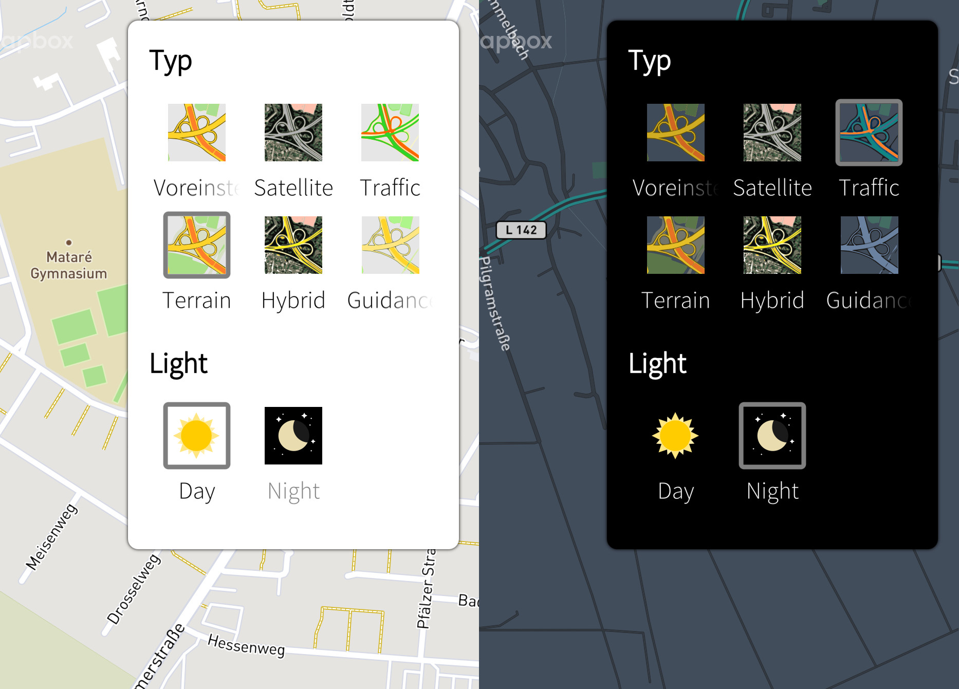
Next round.
Now with dark icons for the non sat types.
The sizes are nicely small now with max80kb 58,5kb for the largest sat image.
EDIT: ran all 12 icons through an svg minifyer that strips out inkscape bloat and long variable names and now they are 160kb smaller, 300kb for all 12 where it was 460kb before
SVGS
Last edited by mosen; 2019-08-15 at 10:28.
Now with dark icons for the non sat types.
The sizes are nicely small now with max
EDIT: ran all 12 icons through an svg minifyer that strips out inkscape bloat and long variable names and now they are 160kb smaller, 300kb for all 12 where it was 460kb before
SVGS
__________________
Watch our weird watchfaces for mighty AsteroidOS
Performance comparison Video Sailfish 2.0 vs 1.1.9 vs 1.1.7
[MC eV] Maemo Community eV membership application please concider to join!
Watch our weird watchfaces for mighty AsteroidOS
Performance comparison Video Sailfish 2.0 vs 1.1.9 vs 1.1.7
[MC eV] Maemo Community eV membership application please concider to join!
Last edited by mosen; 2019-08-15 at 10:28.
| The Following 11 Users Say Thank You to mosen For This Useful Post: | ||
|
|
2019-08-15
, 05:37
|
|
Posts: 1,414 |
Thanked: 7,547 times |
Joined on Aug 2016
@ Estonia
|
#808
|
Thank you very much! Getting closer to the full set . While not used yet well, we are missing preview map type (for map providers without traffic).
I wonder, if for terrain type we should reduce road line width to highlight green area.
. While not used yet well, we are missing preview map type (for map providers without traffic).I wonder, if for terrain type we should reduce road line width to highlight green area.
| The Following 6 Users Say Thank You to rinigus For This Useful Post: | ||
|
|
2019-08-15
, 11:25
|
|
Community Council |
Posts: 1,669 |
Thanked: 10,225 times |
Joined on Nov 2014
@ Lower Rhine
|
#809
|
Originally Posted by rinigus
I would need further explanation on that.
Thank you very much! Getting closer to the full set
where can i visually see what a preview map type is or simply what should be the difference to the current ones.
Originally Posted by rinigus
Reducing line width sounds easier than it is.
I wonder, if for terrain type we should reduce road line width to highlight green area.

The svgs are auto-vectorized and thus have weird cut out mask effects where eg. what you see is a line but in reality the line is an inverted cut out from a layer covering the whole area.
I resorted to playing with saturation and darkness to make the terrain more obvious. Hope it is better.
Also the map-guide icon in last zip+mockup was wrong. I did not put the last version i made. This one should now be clearer and have same line thickness as the others where it was thinner before.
Updated minified zip attached.
__________________
Watch our weird watchfaces for mighty AsteroidOS
Performance comparison Video Sailfish 2.0 vs 1.1.9 vs 1.1.7
[MC eV] Maemo Community eV membership application please concider to join!
Watch our weird watchfaces for mighty AsteroidOS
Performance comparison Video Sailfish 2.0 vs 1.1.9 vs 1.1.7
[MC eV] Maemo Community eV membership application please concider to join!
| The Following 7 Users Say Thank You to mosen For This Useful Post: | ||
|
|
2019-08-15
, 12:16
|
|
Posts: 1,414 |
Thanked: 7,547 times |
Joined on Aug 2016
@ Estonia
|
#810
|
mosen, then let's keep outdoor as it is.
Preview is/will be used by osm scout server. Its shown when route is calculated , but before navigation itself. So, we can imagine map styles highlighting cycling routes, public transport, highways shown at that stage.
Preview is/will be used by osm scout server. Its shown when route is calculated , but before navigation itself. So, we can imagine map styles highlighting cycling routes, public transport, highways shown at that stage.
| The Following 6 Users Say Thank You to rinigus For This Useful Post: | ||