


Active Topics
-
Is there a section to talk about Java ME? Apps, etc. (3)
to General by Kalatti - 18 hrs, 31 mins ago - more...

|
2010-12-01
, 18:33
|
|
Posts: 1,548 |
Thanked: 7,510 times |
Joined on Apr 2010
@ Czech Republic
|
#372
|
Originally Posted by Wikiwide

OK, but it will actually just run once on startup, because thats currently the only time modRana starts the GPS by itself (provided it was not turned off on the last run, in this case modRana respects the setting and wont start the GPS).
Quick reply...
Feature request: in GPS, along with On and Off, add third option: Ask. So that when Modrana wants to turn on GPS, it asks me whether it's needed.
Originally Posted by 白い熊
Yes, it's possible but currently only the ground track is saved, not the directions data, that would be needed to start navigation on the track. I'm working on including the data, either as similarily named file with different extension or directly to the GPX file.
It seems some of this you've already implemented, I just discovered there is the download around route option... Woah, GREAT!!!
Can you save and load routings / not sure this is the same as tracks?
Originally Posted by stenny
When it's done
when will this be promoted to extras-testing?
 On a serious note, a first extras-testing release is definitely planed short to mid term. There are still some features that need to be implemented/fixed (+ documentation update) before doing a first release aimed to extras.
Originally Posted by Tomaszd
So basically:
Great application! Would you consider integrating functionality from my thread about Itinerer Support?
- "click to start" screen on startup
- display trip distance and elapsed time + distance traveled since last click
- some way to reset both counters
Seems doable, I was already planing to add some non-map navigational aids and this would quite fit in (together with that directions + distance indicator)

BTW, modRana already uses the shortest, once-per-second GPS-fix update interval provided by liblocation. Could that be too slow for racing ?
Originally Posted by woody14619
OK, I'll add this to the list of possible navigation startup heuristics
I like the third option (and think it will help). I also would like to propose the following: Trigger on not just the current point, but the point after it. This way, even if it's still focused on a point behind us, once we pass the next point it will auto-fix itself.
Originally Posted by woody14619
As there are maybe already a bit too many of the route buttons I am more thinking about integrating last/next turn switches into the directions frame, like this:
I dislike using one of the buttons for a fix for this though. I would think adding a widget/button to the lower right stack of route buttons would work well for this. (eg "Jump to next point" or "skip this point") It would also allow one to jump to a turn 3 or 4 ahead to trigger on too, and make "robo-phone" quiet during a sequence of turns one already knows well.
|[ hide ][ last ][ next ]|
| |
| turn to X towards Y|
| |
| click to reroute |
IMO, its more apparent like this, that these buttons belong to the directions box.
Originally Posted by woody14619
Were you possibly using map scaling ? If so, it might be related to this ticket. Basically, the scaled map is made from enlarged tiles from a zoomlevel "above", but batch downloader downalods tiles for the current zoomlevel, not the above ones.
I like those options, and highly vote for a restore route on restart. Especially now that there's a top-level button for "clear current route".
Now for the bug list:
So over the holiday, I took modRana on a trip with me, about 800 miles round trip. I found a couple small bugs on the way, three of which were real problems:
1> Despite spending lots of time downloading tiles, when I was in an area that I know downloaded, local tiles were not used. If I turned off (or lost) GSM, I got the "download failed" tiles. And if I switched my data plan setting to "only vital info" I got a grey background. I even had wifi for one stop in the trip, and downloaded tiles for a 20k radius. It said it got all the tiles (and my free space dropped by 200M), but on starting it up and driving, I got the same thing. I have sqlite turned on, and the database files seem to be ok / intact and about the right size. Any ideas?
I'am going to work on fixing this as high priority, just in case.
Originally Posted by woody14619
Definitely something broken in the drawing pipeline, most probably due to processing more tiles than usual due to the speed.
2> After some points I started getting an odd "blinking" when going over 50MPH. It seemed to happen when I was in an area where I only had GSM2.0 (not EDGE or 3G). The screen would draw, but then would go blank (no title bar or map or anything). The GPS would fall behind during this, and the whole device would become non-responsive. After I'd slowed (under 30mph) or stopped for a short time, it would return to normal.
I suspect the automatic tile download mechanism might be causing this. It basically spawns a thread for every tile that is not found in the local storage.
Provided you are moving fast enough and have a bad Internet connection at the same time, there can be quite a few threads that are contesting for bandwidth and each can live for up to 30 seconds, before its connection times out.
I guess a limit on the number of concurrent auto-download threads might be in order.
But this still should not cause a black screen - just a slowdown, so there is probably also something related, that breaks the drawing.
Please consider logging this behavior next time it occurs
Originally Posted by woody14619
Its currently set to fit inside the box, which isn't ideal the reasons you describe. I see two possible ways how to improve this:
3> The text in the box seemed to change size randomly, more based on how long the text was. In may cases it was so tiny as to be illegible unless looked VERY closely at the device.
- wordwrap it to multiple lines
- use a fixed size font and what wont't fit in - the imost important part is always in the beginning after all
Originally Posted by woody14619
Looks interesting, it might indeed speed up some often executed code, like geographic calculations. When working with routes and tracklogs, there is A LOT of coordinate conversions, for all the point that need to be plotted. But it might be quite complicated to properly package for the autobuilder.
Of course, I was driving and didn't turn on debugging, so I have no logs for any of this. :P And I updated to 1.19 just before the trip, so it's the current version.
One more thing to check out: Not sure if modRana is hitting a processing wall (though it seems it may be). This may be something to check out to see if modRana could benefit from it. It compiles python code in to platform specific executable code, and can really speed things up. At least one other app on the N900 is using it.
BTW, this is how dragging the map with a long road displayed looks like:
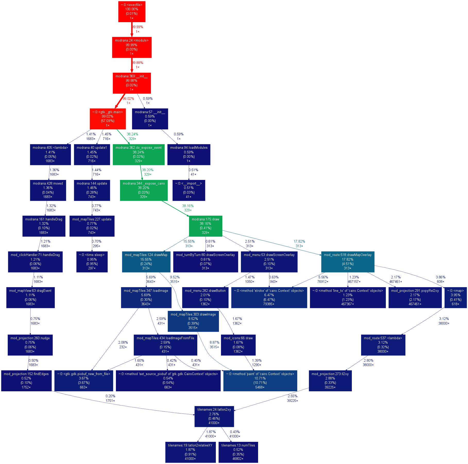
mod_projections, which does most of the conversions, Takes quite a few percent of the combined time modRana used in the expose function.
This is how just dragging the map without any route or tracklog looks like:
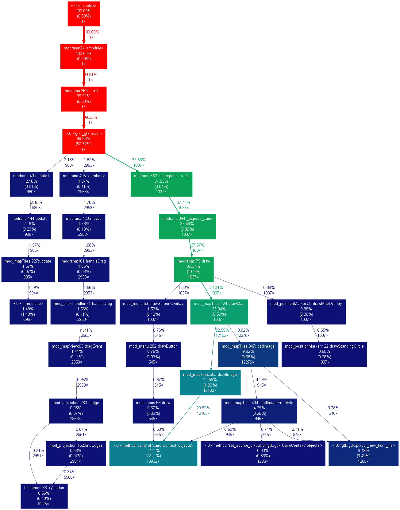
Whole 22% percent is eaten by cairo (bottom left.center) drawing all the bitmaps being moved around (unlike for example Mappero or AGTL, modRana redraws the map during drag). A single screen redraw takes too long, resulting in laggy map dragging. This might be improved by using clutter, which is GPU accelerated to draw the map. Well, yesterday I got running python bindings for Clutter 1.0 compiled and running, so I can slowly start working on it
Originally Posted by woody14619
Thankfully I didn't have to rely on it much, since the voice announcements are now happening more frequently and with more fore-warning.
Originally Posted by woody14619
Um, I haven't added the additional announcement triggers yet
Overall, this trip modRana really did a great job. Minus the tile cache issue, everything went well, and the announcments worked like a charm. (I love the warning a couple miles out btw, much better.)
__________________
modRana: a flexible GPS navigation system
Mieru: a flexible manga and comic book reader
Universal Components - a solution for native looking yet component set independent QML appliactions (QtQuick Controls 2 & Silica supported as backends)
modRana: a flexible GPS navigation system
Mieru: a flexible manga and comic book reader
Universal Components - a solution for native looking yet component set independent QML appliactions (QtQuick Controls 2 & Silica supported as backends)
 |
|
2010-12-01
, 18:49
|
|
Posts: 284 |
Thanked: 498 times |
Joined on Jun 2009
@ Poland
|
#373
|
Originally Posted by MartinK
That's enough for racing
(...)
So basically:?
- "click to start" screen on startup
- display trip distance and elapsed time + distance traveled since last click
- some way to reset both counters
Seems doable, I was already planing to add some non-map navigational aids and this would quite fit in (together with that directions + distance indicator)
BTW, modRana already uses the shortest, once-per-second GPS-fix update interval provided by liblocation. Could that be too slow for racing ?
And yes, an easy access to a one-tap reset action for the trip counter with the trip counter visible and preferrably huge, is essentially what's needed.
__________________
Do you like Extra Decoders Support? Consider donating to support the project.
Do you like Extra Decoders Support? Consider donating to support the project.
|
|
2010-12-01
, 19:21
|
|
Posts: 73 |
Thanked: 33 times |
Joined on Nov 2010
|
#374
|
Originally Posted by MartinK
I've been having lots of these and it is not related to moving. But seems many processes are started and they don't die.
Definitely something broken in the drawing pipeline, most probably due to processing more tiles than usual due to the speed.
I suspect the automatic tile download mechanism might be causing this. It basically spawns a thread for every tile that is not found in the local storage.
Provided you are moving fast enough and have a bad Internet connection at the same time, there can be quite a few threads that are contesting for bandwidth and each can live for up to 30 seconds, before its connection times out.
I guess a limit on the number of concurrent auto-download threads might be in order.
But this still should not cause a black screen - just a slowdown, so there is probably also something related, that breaks the drawing.
What happens to me, I just try to prenavigate an area where I'll be going, basically just look at the map, move the cursor around. After a set period of time of doing this, let's say 10 minutes, it will always black when moving further, i.e. you move the screen more to a new area let's say south of where you are looking, and it turns completely back. If you move it back south to where you were before the move, the tiles appear. It would seem like a memory leak or something.
Anyhow this happens when driving also, notably, when autocentered, the map would turn black, when clicking on the screen, which turned the autocenter off, the map would appear, and the moving cursor, too. Then as I'd be driving it'd move of the map, autocenter again - black, click the screen - the map is there, if autocenter right away - black... And so on...
Very annoying... It looks to bee like too many concurrent processes, or don't know, but it's not downloading the tiles, as they are already there, but still black...
|
|
2010-12-01
, 19:33
|
|
Posts: 1,548 |
Thanked: 7,510 times |
Joined on Apr 2010
@ Czech Republic
|
#375
|
Originally Posted by petur
That might be it, drawing a tracklog is generally more demanding than just showing the map. ModRana also currently always redraws the screen, at least once per second, even with blanked screen. This is quite inefficient and a don't-draw-if-no-one-can-see-it optimization is being worked upon
What I did do on day 2 before leaving was loading the tracklog of day 1 on the map as a reference. Could this have caused more drain?
Originally Posted by petur
These track come as examples for trying out the tracklog management feature. But you have a point, they should be called "example_trackglog_X.gpx" or similar so that their nature would be more apparent.
Just after installing the latest version (0.19-3), I noticed some gpx files under log and misc. Since I cleared out my tracklogs, and they are from a location I've never been, I assume they came with the install.
- Can these be removed from the package?
Originally Posted by petur
Yep, there also already a ticket for this in the list.
- Can you add an option under Tools to delete the tracklog
Originally Posted by petur
Tracklogs are currently stored by default in /opt/modrana/tracklogs, the path can be configured in the /opt/modrana/user_config.conf file under tracklog_folder.
- Can you add an option to set the location where tracklogs get stored, so I can reach them via USB (copy to PC)?
I will be changing the default path to a "tracklogs" folder (or is there already some well known folder other programs use for storing GPX tracklogs ?) in MyDocs in near future, so that the tracklogs are easier to access.
Originally Posted by petur
Well, nothing much, just fixed the context buttons not being hidden with other buttons + made notifications show up when buttons are hidden and fixed directions not respecting language settings. No idea how this should improve performance
By the way... WHAT HAVE YOU DONE to modRana???
It (0.19-3) has become MUCH faster suddenly, the menus are so much more responsive. YAY!
__________________
modRana: a flexible GPS navigation system
Mieru: a flexible manga and comic book reader
Universal Components - a solution for native looking yet component set independent QML appliactions (QtQuick Controls 2 & Silica supported as backends)
modRana: a flexible GPS navigation system
Mieru: a flexible manga and comic book reader
Universal Components - a solution for native looking yet component set independent QML appliactions (QtQuick Controls 2 & Silica supported as backends)
|
|
2010-12-01
, 19:34
|
|
Posts: 739 |
Thanked: 114 times |
Joined on Sep 2009
|
#376
|
So this is not a voice nag app right?
 |
|
2010-12-01
, 22:26
|
|
Posts: 1,455 |
Thanked: 3,309 times |
Joined on Dec 2009
@ Rochester, NY
|
#377
|
Originally Posted by MartinK
Sounds like a plan.
As there are maybe already a bit too many of the route buttons I am more thinking about integrating last/next turn switches into the directions frame, like this:
Originally Posted by MartinK
Nope, I've never quite understood the scaling options, so I've never changed them. I'm actually quite unclear on why I'd want one vs the other.
Were you possibly using map scaling ?
Originally Posted by MartinK
The 30 second thing would fit in place with what I saw. I also had an issue near the end of the trip where it was on/routing for 4+ hours where it complained about "Operation canceled due to lack of memory". I "fixed" that by closing and restarting the app though, as I was semi-lost at the time.
Definitely something broken in the drawing pipeline, most probably due to processing more tiles than usual due to the speed.

Originally Posted by MartinK
I will... how big are the logs it generates with normal usage? If they're small I may just turn it on and let it log everything, then chop out the parts I need later for issues. (I need an on-screen debug widget/button!
Please consider logging this behavior next time it occurs
)
Originally Posted by MartinK
I always like option 3: User setting to choose which one.
Its currently set to fit inside the box, which isn't ideal the reasons you describe. I see two possible ways how to improve this:
Originally Posted by MartinK
There was mention in the article about another project for N900 using it. You may be able to get hints on it from that package maintainer? If you're not hitting a wall yet though, no big reason to pull it in right away. If on-device tiling causes contention later though, this may be helpful.
Looks interesting, ... But it might be quite complicated to properly package for the autobuilder.
Originally Posted by MartinK
Wow.. nice map. What profiler are you using to generate that? Is it just for python? I code mainly in C/C#/C++, so not too familiar with python and it's tool set. Nice look to it though.
BTW, this is how dragging the map with a long road displayed looks like:
Originally Posted by MartinK
Hmm... Odd. It's been much better about warning 3 to 4 miles out since the update to 19. Maybe it works better on trips with longer distances between points? Is the length of the segment used at all to compute how early to trigger?
Um, I haven't added the additional announcement triggers yet
Overall, sounds like you've got plenty on the plate to work with. I'll happily test things out with new releases as they come out!
I'm also hopeful to getting things setup (build env, etc) this weekend to start porting the tile server. I probably won't have a release before Monday, but if things go smoothly... we'll see.
| The Following User Says Thank You to woody14619 For This Useful Post: | ||
|
|
2010-12-01
, 23:10
|
|
Posts: 4,556 |
Thanked: 1,624 times |
Joined on Dec 2007
|
#378
|
This might be a silly question but I couldn't find it in the menu or on screen menu. Is there a way to see all the directions at once? When I'm the navigator my fiancee often wants me to tell her the next two or three steps which I can't seem to do with Modrana.
__________________
Originally Posted by ysss
They're maemo and MeeGo...
"Meamo!" sounds like what Zorro would say to catherine zeta jones... after she slaps him for looking at her dirtily...
|
|
2010-12-02
, 06:53
|
|
Posts: 1,994 |
Thanked: 3,342 times |
Joined on Jun 2010
@ N900: Battery low. N950: torx 4 re-used once and fine; SIM port torn apart
|
#379
|
That's strange, but after the latest update I see no buttons, no menu.
Here is log from X Terminal.
Here is log from X Terminal.
|
|
2010-12-02
, 19:21
|
|
Posts: 73 |
Thanked: 33 times |
Joined on Nov 2010
|
#380
|
The batch download might be buggy. I've been trying to download a 40km area in this webcafe for ages, can't get it done.
The log shows it's going fine for a while:
Batch tile dl working... (threads: 7) pending: 86618, done: 3608
...
Then
exception in get tiles thread:
database is locked
....
a number of times. Then the download seems to go on, but much much faster, super fast, which is impossible, and of course the tiles are not downloaded...
 |
| Tags |
| bada rox, martin_rocks, modrana, navigation, openstreetmap, the best, wehasgps |
«
Previous Thread
|
Next Thread
»
|
All times are GMT. The time now is 19:34.
i
However, I realized that it has to do with a usage pattern. If you select route->address to address and then click on "start" with the keyboard closed, you'll get the on-screen keyboard and you can see what you're typing with no problem. But if you open the keyboard, you'll get a little dialog window at the bottom fo the screen that reads "Input the start address". That one uses a black font on a black background. You can see the text if you swipe to select it, which changes the background to light blue.
I don't see anything in user_config.conf to control font colors. I don't have a .gtkrc controlling anything. However, after a bit of exploring, I found that I could modify mod_textEntry.py to fix the problem. After the line:
entry.modify_text(gtk.STATE_NORMAL, gtk.gdk.color_parse('#ffffff'))Hopefully, this post will give somebody who knows more about gtk what they need to fix this bug.