


Active Topics
-
Is there a section to talk about Java ME? Apps, etc. (7)
to General by teroyk - 3 hrs, 19 mins ago - more...

| The Following User Says Thank You to aRTee For This Useful Post: | ||

|
2012-02-12
, 09:11
|
|
Posts: 37 |
Thanked: 21 times |
Joined on May 2010
|
#12
|
Hi,
How can I specify where map data is stored/cached?
At the moment it is hardcoded on MyDocs vfat partition, it means, that I cannot use symlinks to specify, where the data should land. I would like to use the same cache shared between many applications.
TIA
Paul
How can I specify where map data is stored/cached?
At the moment it is hardcoded on MyDocs vfat partition, it means, that I cannot use symlinks to specify, where the data should land. I would like to use the same cache shared between many applications.
TIA
Paul
|
|
2012-02-12
, 10:32
|
|
Posts: 77 |
Thanked: 42 times |
Joined on Oct 2011
@ Sofia, Bulgaria
|
#13
|
Hi,
Great work!! I have a small feature request:
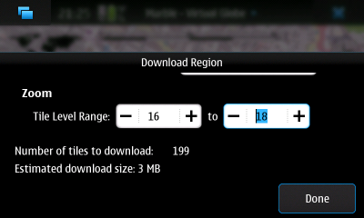
Can you include the option to download tiles for the visible region for a range of zoom levels, like on the n900?
Great work!! I have a small feature request:
Can you include the option to download tiles for the visible region for a range of zoom levels, like on the n900?
| The Following User Says Thank You to YavkatA For This Useful Post: | ||
|
|
2012-02-12
, 18:27
|
|
Posts: 37 |
Thanked: 21 times |
Joined on May 2010
|
#14
|
Another bug...
The routing daemon does not quit when marble quits. As a result you cannot use N9 as a USB mass storage device, because the routing daemon is using data from ~/MyDocs and therefore the vfat partition cannot be unmounted in order to switch to the mass storage mode when USB connected.
Solution 1: kill routing daemon when marble quits
Soultion 2: (additionally to #1) let the user decide where the routing and map cache data is stored. Use directory in ~/.local/share/marble/.... and make soft link to ~/MyDocs/.local/share/marble/...
Paul
|
|
2012-02-13
, 20:12
|
|
Posts: 188 |
Thanked: 90 times |
Joined on Sep 2006
|
#15
|
@Paul
what if you stop routing first, then quit marble?
I mean, until the bug is fixed, with your proposal Solution 1, that is...
BTW the solution 2 you propose is not very acceptable, since the ~/.local data is on a relatively small partition, not one where the user will be happy to have 100s of MB of map data...
Another point/feature request: for routing, if one drags the route, there will be a new waypoint inserted and the route will pass along that new point - as soon as there are 3 points, it would be good if each of those could be deleted individually; now if one clicks the edit pen symbol, one gets the choice for select on map and current location, it would be good to get an additional option: delete point.
__________________
If I said something useful, please hit the 'Thanks!' link related to that post.
If I said something useful, please hit the 'Thanks!' link related to that post.
| The Following User Says Thank You to aRTee For This Useful Post: | ||
|
|
2012-02-13
, 22:42
|
|
Posts: 87 |
Thanked: 535 times |
Joined on Oct 2010
@ Karlsruhe, Germany
|
#16
|
Originally Posted by aRTee

No, your answers are appreciated ;-)
Hi earthwings, thanks a lot for your complete answers!
BTW apologies for my attempt to answer questions that were directed at you, please correct my comments as required - I just wouldn't want to keep you from coding.

Originally Posted by aRTee
I changed it to close on the next click now. Currently that also closes it when panning, I hope I can fix that until the next release.
BTW thanks for the info on how to get rid of things; all logical on second thought - and I figured some out today, except for the popup where one has to click on it, but not on the route button...
I think that's not so intuitive to have to click the popup, but just around the button... on a resistive screen like the N900 or my old N700 that would be fine, but capacitive touch needs more leeway IMHO...
Originally Posted by aRTee
It shows "100 (or so) brightest" from http://celestrak.com/NORAD/elements/
Some more questions and comments:
- the show satellite option on the space view seems to show a lot more than just geolocation sats (think I saw good ole Astra on the list, etc), and I guess that data comes from the web.
Marble's Desktop version let's you configure further which satellites are visible.
Originally Posted by aRTee
That's a cool idea. Can you file a bug report (wishlist)? Would also be nice to have that for the Desktop version.
If there's no data connection, will it show the GPS sats that the system has ephemeris data for (as soon as it has data, even before a fix)?
That would be much much cooler than the regular spiderweb view, especially if some kind of colour change would indicate the sat reception strength and whether it's momentarily in use for GPS positioning...!
Originally Posted by aRTee
That should be fixed in 1.3.2 already. If not, in 1.3.3, the version on my N950 already has the fix at least.
- when moving in space view with show sats to venus or so, the sats are happily flying around venus... I guess when changing away from Earth, the show sats and clouds should be off...
Originally Posted by aRTee
Yes, indeed. I couldn't decide how to implement it nicely so far.
- when setting up a route, one can edit a point as per the "current location", or "select in map" (btw I think it should be 'select on map' but I'm not a native speaker...). I figured out that the various views from the general menu are all very linked, so one can choose 'select on map', then go back to the general menu, then into Search, then find a street/place with the search function, then click one of the search results (which shifts the map to that point), then choose the appearing route button, or just go back to the Route section, where the previous map is then in view, and touch a place on the map to be used.
I think alongside the Select on map and Current location, it would be good to have a third option Search, which would have one jump directly to the search section, and after seaching, when going back, have the view come back directly to the Route view...
Originally Posted by aRTee
Monav can't handle that currently unfortunately. You'll either need larger maps or route to the borders.
- if one installs maps of adjoining regions, say Germany, Switzerland and Italy, can Marble / Monad then route all across?
(I once asked Navit devs this question about Navit, which can't do route across different maps...)
From how things are set up, I'm guessing it should be ok also with offline routing data, but it would be good to have confirmation...
Originally Posted by aRTee
Thanks for reporting, I know what's wrong and added it to the todo list.
- I was navigating earlier today, and when turning on the height profile, then turning it off again, the white position/directional arrow disappeared, as well as the signal precision red halo.
Going out and coming back (also doing a route from current location) brought things back...
Originally Posted by aRTee
Yes, here. Currently it's building an intermediate version 1.3.2.1 with initial, incomplete bookmark support. Feel free to test, but note that this gets updated with very little testing, so there'll be more bugs than in the version in the Ovi store.
- is there any place from where I can download current / latest versions other than Ovi Store? Perhaps it's good if some people test the waters..?
To use it, open a root terminal on the N9/N950 (devel-su, password rootme on the N950) and create the file /etc/apt/sources.list.d/marble-experimental.list with the content (one line)
Code:
deb http://repo.pub.meego.com/home:/shentey/MeeGo_1.2_Harmattan_Maemo.org_MeeGo_1.2_Harmattan_standard/ ./
Code:
apt-get update
apt-get install marble
Code:
apt-get remove marble
Originally Posted by Paul Ortyl
It's possible to change the .dgml file associated with a map theme in /opt/marble/share/... to cache the data in an absolute directory of your choice. That's how we use a shared "OpenStreetMap I" directory on the N900 (via a post-install hook in the packages).
How can I specify where map data is stored/cached?
At the moment it is hardcoded on MyDocs vfat partition, it means, that I cannot use symlinks to specify, where the data should land. I would like to use the same cache shared between many applications.
Is there some similar common directory on the N9 used by several applications?
Originally Posted by YavkatA
I left it out for 1.3.2 to think a bit more on the user interface. The best solution I have in mind so far is to integrate it in the "Prepare offline usage" dialog in the Routing activity (so you can either download along the route or the currently visible region). The drawback is that people might expect it elsewhere as well (I'd expect to download tiles along the route only in the routing activity, but downloading tiles for the visible region would suit in other activities as well).
Can you include the option to download tiles for the visible region for a range of zoom levels, like on the n900?
Originally Posted by Paul Ortyl
Marble already implements Solution 1, the routing daemon is terminated when Marble quits and that works reliably on my phone. I know of a bug that can lead to Marble not quitting correctly, but sitting idle in the background waiting infinitely for some network connection that failed. It might be related to that. Are you using a N9 or N950? Which software version?
The routing daemon does not quit when marble quits. As a result you cannot use N9 as a USB mass storage device, because the routing daemon is using data from ~/MyDocs and therefore the vfat partition cannot be unmounted in order to switch to the mass storage mode when USB connected.
Solution 1: kill routing daemon when marble quits
Soultion 2: (additionally to #1) let the user decide where the routing and map cache data is stored. Use directory in ~/.local/share/marble/.... and make soft link to ~/MyDocs/.local/share/marble/...
Originally Posted by aRTee
So far I deactivated that feature because it triggers a crash; I think it's a bug in QML as it's easy to reproduce (a MouseArea in a ListView delegate that triggers its own deletion leads to a crash). I didn't find a sane fix so far.
Another point/feature request: for routing, if one drags the route, there will be a new waypoint inserted and the route will pass along that new point - as soon as there are 3 points, it would be good if each of those could be deleted individually; now if one clicks the edit pen symbol, one gets the choice for select on map and current location, it would be good to get an additional option: delete point.
__________________
Marble - Find your way and explore the world with your N900 or N9 | Your voice counts!
Marble - Find your way and explore the world with your N900 or N9 | Your voice counts!
|
|
2012-02-13
, 23:38
|
|
Posts: 77 |
Thanked: 42 times |
Joined on Oct 2011
@ Sofia, Bulgaria
|
#17
|
Originally Posted by earthwings
The first place I looked for this option was in Offline Data, under Data Management in the Preferences dialog. I think that this might be a good place to offer this option, because, as you say, people might expect to see it elsewhere and not only in Routing.
I left it out for 1.3.2 to think a bit more on the user interface. The best solution I have in mind so far is to integrate it in the "Prepare offline usage" dialog in the Routing activity (so you can either download along the route or the currently visible region). The drawback is that people might expect it elsewhere as well (I'd expect to download tiles along the route only in the routing activity, but downloading tiles for the visible region would suit in other activities as well).
|
|
2012-02-14
, 15:24
|
|
Posts: 188 |
Thanked: 90 times |
Joined on Sep 2006
|
#18
|
Thanks again earthwings for all your efforts!
I got the preview version installed, no problem. Pinch zooming etc is ok now, thanks. Didn't have much time to try out other things, hope to have more time tonight...
Another thing I noticed is that the elevation profile starts at 0 (y-axis scale); living and moving around in Switzerland / Zurich area this makes it hard to distinguish altitude variation nicely,...
For cycling / jogging, up and down by 50 m is quite a bit, but if the base is around 400m, 50 m delta is hardly a blip...
Since 0m is also a relatively arbitrary level, I would say the y-scale should fit to the range. That would also make it easier to read the min and max elevation of a track.
Originally Posted by earthwings
Done: https://bugs.kde.org/show_bug.cgi?id=294076Originally Posted by aRTeeThat's a cool idea. Can you file a bug report (wishlist)? Would also be nice to have that for the Desktop version.If there's no data connection, will it show the GPS sats that the system has ephemeris data for (as soon as it has data, even before a fix)?
That would be much much cooler than the regular spiderweb view, especially if some kind of colour change would indicate the sat reception strength and whether it's momentarily in use for GPS positioning...!
I got the preview version installed, no problem. Pinch zooming etc is ok now, thanks. Didn't have much time to try out other things, hope to have more time tonight...
Another thing I noticed is that the elevation profile starts at 0 (y-axis scale); living and moving around in Switzerland / Zurich area this makes it hard to distinguish altitude variation nicely,...
For cycling / jogging, up and down by 50 m is quite a bit, but if the base is around 400m, 50 m delta is hardly a blip...
Since 0m is also a relatively arbitrary level, I would say the y-scale should fit to the range. That would also make it easier to read the min and max elevation of a track.
__________________
If I said something useful, please hit the 'Thanks!' link related to that post.
If I said something useful, please hit the 'Thanks!' link related to that post.
|
|
2012-02-17
, 09:59
|
|
Posts: 188 |
Thanked: 90 times |
Joined on Sep 2006
|
#19
|
Something else: the satellites are shown in a very unrealistic way: much to close to the earths surface.
http://www.kowoma.de/en/gps/orbits.htm shows the GPS altitude, and geosynchronous orbits (such as for Astra) are shown nicely here: http://www.daviddarling.info/encyclo...ary_orbit.html and on wikipedia.
But then again, I'm not sure what kind of realism is desirable/doable.
I also don't know for which satellites (of the top100) altitude data is actually available.
Edit: see this page with real view:
http://science.nasa.gov/realtime/jtr...JTrack3D.html/
Last edited by aRTee; 2012-02-17 at 13:05. Reason: added Jtrack
http://www.kowoma.de/en/gps/orbits.htm shows the GPS altitude, and geosynchronous orbits (such as for Astra) are shown nicely here: http://www.daviddarling.info/encyclo...ary_orbit.html and on wikipedia.
But then again, I'm not sure what kind of realism is desirable/doable.
I also don't know for which satellites (of the top100) altitude data is actually available.
Edit: see this page with real view:
http://science.nasa.gov/realtime/jtr...JTrack3D.html/
__________________
If I said something useful, please hit the 'Thanks!' link related to that post.
If I said something useful, please hit the 'Thanks!' link related to that post.
Last edited by aRTee; 2012-02-17 at 13:05. Reason: added Jtrack
| The Following User Says Thank You to aRTee For This Useful Post: | ||
|
|
2012-02-20
, 09:55
|
|
Posts: 4 |
Thanked: 8 times |
Joined on Dec 2010
@ Nuremberg
|
#20
|
Originally Posted by aRTee
The positions provided in Marble are realistic and correct:
Something else: the satellites are shown in a very unrealistic way: much to close to the earths surface.
Actually the top 100 satellites/spacecrafts _are_ "close" to the earth's surface: Take the ISS for example which orbits at a height of 380 kms above earth (which equals about 3% of the earth's diameter) . Same for the HST which travels at a height of about 550km around our shiny blue Marble.
Many of the bright satellites are just orbiting closely to the atmosphere which is just a very thin layer on top of the earth's surface.
Originally Posted by aRTee
For the geostationary orbit (like GPS satellites) the situation is different indeed. However those are not enabled in Marble by default. If you enable them (this might only be possible easily in the desktop version) you'll see that the GPS satellites are indeed rendered by Marble just like in the pictures you show: at a height of about 35800 km.
http://www.kowoma.de/en/gps/orbits.htm shows the GPS altitude, and geosynchronous orbits (such as for Astra) are shown nicely here: http://www.daviddarling.info/encyclo...ary_orbit.html and on wikipedia.
Originally Posted by aRTee
We verified the positions and altitudes for a few satellites (we had this verified even by people who do this satellite stuff professionally) and so far up to our knowledge the positions are correct (except for the rare case of very elliptic satellite orbits where there is a slight minor difference to the actual position). If you still think that you have found some bug regarding the position of a certain satellite please tell us the name of the satellite and the time for which you tested and we will check.
But then again, I'm not sure what kind of realism is desirable/doable. I also don't know for which satellites (of the top100) altitude data is actually available.
Last edited by tackat; 2012-02-20 at 09:58.
| The Following User Says Thank You to tackat For This Useful Post: | ||
BTW apologies for my attempt to answer questions that were directed at you, please correct my comments as required - I just wouldn't want to keep you from coding.
BTW thanks for the info on how to get rid of things; all logical on second thought - and I figured some out today, except for the popup where one has to click on it, but not on the route button...
I think that's not so intuitive to have to click the popup, but just around the button... on a resistive screen like the N900 or my old N700 that would be fine, but capacitive touch needs more leeway IMHO...
Some more questions and comments:
- the show satellite option on the space view seems to show a lot more than just geolocation sats (think I saw good ole Astra on the list, etc), and I guess that data comes from the web.
If there's no data connection, will it show the GPS sats that the system has ephemeris data for (as soon as it has data, even before a fix)?
That would be much much cooler than the regular spiderweb view, especially if some kind of colour change would indicate the sat reception strength and whether it's momentarily in use for GPS positioning...!
- when moving in space view with show sats to venus or so, the sats are happily flying around venus... I guess when changing away from Earth, the show sats and clouds should be off...
- when setting up a route, one can edit a point as per the "current location", or "select in map" (btw I think it should be 'select on map' but I'm not a native speaker...). I figured out that the various views from the general menu are all very linked, so one can choose 'select on map', then go back to the general menu, then into Search, then find a street/place with the search function, then click one of the search results (which shifts the map to that point), then choose the appearing route button, or just go back to the Route section, where the previous map is then in view, and touch a place on the map to be used.
I think alongside the Select on map and Current location, it would be good to have a third option Search, which would have one jump directly to the search section, and after seaching, when going back, have the view come back directly to the Route view...
- if one installs maps of adjoining regions, say Germany, Switzerland and Italy, can Marble / Monad then route all across?
(I once asked Navit devs this question about Navit, which can't do route across different maps...)
From how things are set up, I'm guessing it should be ok also with offline routing data, but it would be good to have confirmation...
- I was navigating earlier today, and when turning on the height profile, then turning it off again, the white position/directional arrow disappeared, as well as the signal precision red halo.
Going out and coming back (also doing a route from current location) brought things back...
- is there any place from where I can download current / latest versions other than Ovi Store? Perhaps it's good if some people test the waters..?
If I said something useful, please hit the 'Thanks!' link related to that post.