


Active Topics
-
Is there a section to talk about Java ME? Apps, etc. (6)
to General by Kalatti - 6 days, 1 hr ago - more...
| The Following 5 Users Say Thank You to Wikiwide For This Useful Post: | ||

|
2013-03-24
, 14:04
|
|
Posts: 1,548 |
Thanked: 7,510 times |
Joined on Apr 2010
@ Czech Republic
|
#1312
|
Originally Posted by Wikiwide

Thanks for the pointer - looks like I'm getting it too. The weird thing is that the icons actually show in the GUI. Anyway, I'll investigate.
Quick question...
Has anybody recently started modrana-qml on N900 from X-Terminal? Because it seems to give a lot of errors about failing to load an icon - because rWin.mTheme is equal to "" instead of "default", and the path becomes "image://icons//name.png". I would say that rWin is somehow not loaded in time. But I cannot be sure.

BTW, rWin is the variable than contains the root window, which is currently instantiated from qml_harmattan/main.qml
Originally Posted by Wikiwide
Good idea! The root window has no mode property yet, but as mode indeed is an important connect in modRana, I'll add a new property that exposes it to QML in an easy to use way.
I have also been trying to get the "menu" icon to show the mode - train, bicycle, bus, whatever - similarly to GTK UI, and rWin.mode seems to be undefined...
Best wishes.
BTW, I've also integrated + extended your multi-layer idea (the code is already on Github) and I'm getting it ready for release.
__________________
modRana: a flexible GPS navigation system
Mieru: a flexible manga and comic book reader
Universal Components - a solution for native looking yet component set independent QML appliactions (QtQuick Controls 2 & Silica supported as backends)
modRana: a flexible GPS navigation system
Mieru: a flexible manga and comic book reader
Universal Components - a solution for native looking yet component set independent QML appliactions (QtQuick Controls 2 & Silica supported as backends)
| The Following 3 Users Say Thank You to MartinK For This Useful Post: | ||
|
|
2013-03-24
, 17:28
|
|
Posts: 1,548 |
Thanked: 7,510 times |
Joined on Apr 2010
@ Czech Republic
|
#1313
|
So I've exposed the mode using the modrana QML context property. So to get the current mode, just use it like this anywhere in the QML code:
modrana.mode is a R/W sub-property, so it can be also used to set the current mode, modRana-wide:
I've also fixed the theme related errors by specifying the modrana.theme sub property. It was probably caused by the root window not being completely loaded at startup. On the other hand, context properties are set before the main loop is started and the view shown, so it should not have this problem any more.
Code:
modrana.mode
Code:
modrana.mode = "car"
__________________
modRana: a flexible GPS navigation system
Mieru: a flexible manga and comic book reader
Universal Components - a solution for native looking yet component set independent QML appliactions (QtQuick Controls 2 & Silica supported as backends)
modRana: a flexible GPS navigation system
Mieru: a flexible manga and comic book reader
Universal Components - a solution for native looking yet component set independent QML appliactions (QtQuick Controls 2 & Silica supported as backends)
|
|
2013-03-24
, 22:17
|
|
Posts: 1,548 |
Thanked: 7,510 times |
Joined on Apr 2010
@ Czech Republic
|
#1314
|
modRana 0.40.1 has been released !
The main highlight of this release is map overlay support in the QML GUI, based on Wikiwides proof of concept (thanks ! ).

Main map sets the background layer and returns to the map screen. The Overlays button switches to the overlay configuration page.
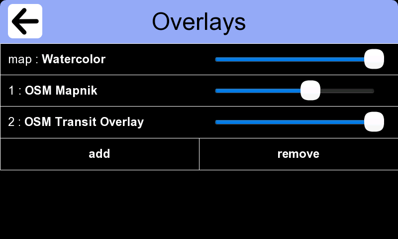
The Overlays page can be used to:
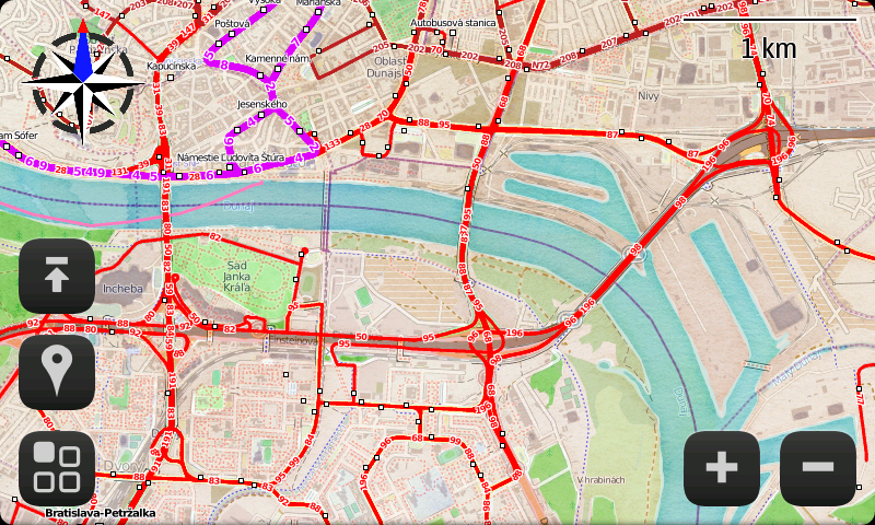
This is how the map configured on the previous screenshot looks like.

When the tiles are being downloaded, a pretty printed status text is shown. The layers are loaded independently, so this status indicator can be used which layer has problems with tile loading, etc.
For now, the overlays are not persistent, but that is on my TODO list. Another thing on my TODO: showing a full layer list in the QML GUI (for now it has a hardcoded layer list).
BTW, there is no hard limit on the number of overlays used at once - and the N900 seems to have no issues even with 5+ layers.
Also an in my opinion important UI enahncement has been added - long pressing the back arrow takes you to the map screen - (already work like this in the GTK GUI).
Changelog:
Last edited by MartinK; 2013-03-24 at 22:22.
The main highlight of this release is map overlay support in the QML GUI, based on Wikiwides proof of concept (thanks !
).Main map sets the background layer and returns to the map screen. The Overlays button switches to the overlay configuration page.
The Overlays page can be used to:
- add or remove overlays
- set overlay opacity
- set layer for a given overlay and the main map
This is how the map configured on the previous screenshot looks like.
- background - Stamen Watercolor
- overlay 1 - Mapnik @ 60% opacity
- overlay 2 - OSM Transit @ 100% opacity
When the tiles are being downloaded, a pretty printed status text is shown. The layers are loaded independently, so this status indicator can be used which layer has problems with tile loading, etc.
For now, the overlays are not persistent, but that is on my TODO list.
Another thing on my TODO: showing a full layer list in the QML GUI (for now it has a hardcoded layer list).BTW, there is no hard limit on the number of overlays used at once - and the N900 seems to have no issues even with 5+ layers.
Also an in my opinion important UI enahncement has been added - long pressing the back arrow takes you to the map screen - (already work like this in the GTK GUI).
Changelog:
Code:
* Sun Mar 24 2013 Martin Kolman - 0.40.1
- map overlay support in QML GUI
 - based on a patch by Wikiwide - thanks ! :)
 - multiple overlays can be used at the same time
 - per-layer opacity setting
 - nice overlay configuration UI
 - there is no hard limit on number of overlays at once
  - too many layers at once might slow down the application though :)
 - overlay configuration is not yet persistent
- pretty print map layer loading status
 - also make sure they don't overlap when overlays are used
- long back-button press now returns to map screen
- some new map layers were added to the QML map layer selector
 - eventually it should use the same layer list as the GTK GUI
- fix some warnings at startup
- theme and mode are now exposed by the "modrana" QML context property
__________________
modRana: a flexible GPS navigation system
Mieru: a flexible manga and comic book reader
Universal Components - a solution for native looking yet component set independent QML appliactions (QtQuick Controls 2 & Silica supported as backends)
modRana: a flexible GPS navigation system
Mieru: a flexible manga and comic book reader
Universal Components - a solution for native looking yet component set independent QML appliactions (QtQuick Controls 2 & Silica supported as backends)
Last edited by MartinK; 2013-03-24 at 22:22.
| The Following 10 Users Say Thank You to MartinK For This Useful Post: | ||
|
|
2013-03-25
, 12:01
|
|
Posts: 1,680 |
Thanked: 3,685 times |
Joined on Jan 2011
|
#1315
|
I am trying to add my own map source to modrana. Microsoft/bing (boo!) maps offer UKOS maps. These are some of the nicest maps available for the UK. I was able to add them to marble with this server string:
In the above example, the 'query="g=41&productSet=mmOS"' is where the magic happens. This is appended to the end of the URL and makes the server return UKOS map tiles instead of virtual earth tiles.
I do not see how to add this parameter to the modrana map config file URL.
Any help?
Code:
<downloadUrl protocol="http" host="ecn.t1.tiles.virtualearth.net" path="/tiles/r{quadIndex}.png" query="g=41&productSet=mmOS" />
I do not see how to add this parameter to the modrana map config file URL.
Any help?
__________________
N900: One of God's own prototypes. A high-powered mutant of some kind never even considered for mass production. Too weird to live, and too rare to die.
|
|
2013-03-26
, 10:54
|
|
Posts: 188 |
Thanked: 308 times |
Joined on Jan 2013
@ UK
|
#1316
|
Originally Posted by vi_
That would be very nice, but even more so offline as when I use OS it tends to be in poor signal areas. The thing is, Bing license the maps from the OS and probably pay a hefty fee, as well as having to restrict their use. I did try and see if it was possible to download the tiles offline, but I messed up the url and got ve tiles. I might try again at some point, but am not optimistic.
I am trying to add my own map source to modrana. Microsoft/bing (boo!) maps offer UKOS maps. These are some of the nicest maps available for the UK. I was able to add them to marble with this server string:
In the above example, the 'query="g=41&productSet=mmOS"' is where the magic happens. This is appended to the end of the URL and makes the server return UKOS map tiles instead of virtual earth tiles.Code:<downloadUrl protocol="http" host="ecn.t1.tiles.virtualearth.net" path="/tiles/r{quadIndex}.png" query="g=41&productSet=mmOS" />
I do not see how to add this parameter to the modrana map config file URL.
Any help?
As for online, can't help there, unfortunately, but watching Bing maps when using them, they do have multiple servers that they seem to round-robin access - ecn.t0...ecn.t1....ecn.t2...ecn.t3....ecn.t4...
|
|
2013-03-26
, 12:28
|
|
Posts: 1,680 |
Thanked: 3,685 times |
Joined on Jan 2011
|
#1317
|
Originally Posted by skanky
Yes it is entirely possible to get the OS map tiles.
That would be very nice, but even more so offline as when I use OS it tends to be in poor signal areas. The thing is, Bing license the maps from the OS and probably pay a hefty fee, as well as having to restrict their use. I did try and see if it was possible to download the tiles offline, but I messed up the url and got ve tiles. I might try again at some point, but am not optimistic.
As for online, can't help there, unfortunately, but watching Bing maps when using them, they do have multiple servers that they seem to round-robin access - ecn.t0...ecn.t1....ecn.t2...ecn.t3....ecn.t4...
I convinced Dwarzdyn to include quad-tree map sources in cloudgps so I could use OS maps. Unfortunatley, Dwardz has moved onto other things so cloudgps has become abandonware, which is a real shame because it was *nice*.
I then started using marble maps and wrote the UKOS map profile for it, it worked quite well but now marble maps has ceased development on the n900. *sigh*.
So AFAIK the last, currently developed map program for the n900 is Modrana. If all the other map programs can grab the map tiles, so can Modrana.
There are 4 servers numbered t1 to t4. You can just use one if you wish but I guess download speed will suffer. I never noticed a problem on cloudgps. If you do not supply the magic string at the end you just get bing satellite images. So the question is, how do I specify a parameter to be added to the end of the URL?
Code:
ecn.t1.tiles.virtualearth.net/tiles/r/<quadindex>.png&g=41&productSet=mmOS
__________________
N900: One of God's own prototypes. A high-powered mutant of some kind never even considered for mass production. Too weird to live, and too rare to die.
|
|
2013-03-26
, 15:24
|
|
Posts: 1,548 |
Thanked: 7,510 times |
Joined on Apr 2010
@ Czech Republic
|
#1318
|
Originally Posted by vi_
There were quite a few others that got discontinued:
Yes it is entirely possible to get the OS map tiles.
I convinced Dwarzdyn to include quad-tree map sources in cloudgps so I could use OS maps. Unfortunatley, Dwardz has moved onto other things so cloudgps has become abandonware, which is a real shame because it was *nice*.
I then started using marble maps and wrote the UKOS map profile for it, it worked quite well but now marble maps has ceased development on the n900. *sigh*.
- Geeps
- Yosmapa
- Monav GUI
- AGTL for N900
- Sygic
Originally Posted by vi_
I think there that booth Navit and Mapsi are still under development.
So AFAIK the last, currently developed map program for the n900 is Modrana.
Originally Posted by vi_
I've just released 0.41.2, it has a new coordinate type called quadtree_substitution that can be used like this:
If all the other map programs can grab the map tiles, so can Modrana.
There are 4 servers numbered t1 to t4. You can just use one if you wish but I guess download speed will suffer. I never noticed a problem on cloudgps. If you do not supply the magic string at the end you just get bing satellite images. So the question is, how do I specify a parameter to be added to the end of the URL?
Code:ecn.t1.tiles.virtualearth.net/tiles/r/<quadindex>.png&g=41&productSet=mmOS
Code:
url="http://tiles.virtualearth.net/tiles/r${quadindex}?g=41&productSet=mmOS"
I've recently added a similar coordinate type for the usual zoom, x & y tile coordinates:
Code:
url="http://vec01.maps.yandex.net/tiles?l=map&x=${x}&y=${y}&z=${z}"
It reminds me a bit of the Soviet-military maps layer. In unfortunately uses some funky WMS-based addressing (the tiles are specified by they geographic coordinates) so I've not yet been able to add it to modRana.
Originally Posted by skanky
Most bigger tile servers have multiple domains due to single-download-thread per domain in browser Javascript. I might be good to add support for using them in modRana too.
As for online, can't help there, unfortunately, but watching Bing maps when using them, they do have multiple servers that they seem to round-robin access - ecn.t0...ecn.t1....ecn.t2...ecn.t3....ecn.t4...
__________________
modRana: a flexible GPS navigation system
Mieru: a flexible manga and comic book reader
Universal Components - a solution for native looking yet component set independent QML appliactions (QtQuick Controls 2 & Silica supported as backends)
modRana: a flexible GPS navigation system
Mieru: a flexible manga and comic book reader
Universal Components - a solution for native looking yet component set independent QML appliactions (QtQuick Controls 2 & Silica supported as backends)

 |
| Tags |
| bada rox, martin_rocks, modrana, navigation, openstreetmap, the best, wehasgps |
«
Previous Thread
|
Next Thread
»
|
All times are GMT. The time now is 04:53.
Has anybody recently started modrana-qml on N900 from X-Terminal? Because it seems to give a lot of errors about failing to load an icon - because rWin.mTheme is equal to "" instead of "default", and the path becomes "image://icons//name.png". I would say that rWin is somehow not loaded in time. But I cannot be sure. I have also been trying to get the "menu" icon to show the mode - train, bicycle, bus, whatever - similarly to GTK UI, and rWin.mode seems to be undefined...
Best wishes.