


Active Topics
-
Is there a section to talk about Java ME? Apps, etc. (0)
to General by Kalatti - 2 days, 13 hrs ago -
Extra softwares in Sailfish using CLI, repositories, etc (117)
to SailfishOS by nieldk - 4 days, 10 hrs ago -
Firefox with Leste (6)
to Maemo 7 / Leste by teroyk - 5 days, 7 hrs ago - more...

| The Following 8 Users Say Thank You to pacman For This Useful Post: | ||

|
2019-08-05
, 18:01
|
|
Posts: 1,414 |
Thanked: 7,547 times |
Joined on Aug 2016
@ Estonia
|
#792
|
@pichlo - entertaining and informative, as usual!
RE Search order (2): That would depend strongly on the provider. For providers other than OSM Scout Server, I cannot do much. Except, I am planning to add location awareness. This is planned soon (no TM, an expected out-of-SFOS-community-meaning). As for filtering by other means, not sure all providers support it. I will have to look into it. Please come back if location aware search will not help.
RE History (3): Navigation history and search histories are remembered separately. "To", "From" are merged with search history. Navigation is added to the history when the routing was successful. Its mainly for historical reasons, but still made sense to me.
Routing on/off highway (4): Have experienced it myself few times in Sweden. For OSM Scout Server, there is no need to submit bug reports yet - I have to update to the latest Valhalla first. After that, we should submit cases to Valhalla issues.
Routing, continue for ... (5): Again, should report to Valhalla after its updated. Not sure what's the version of Valhalla is for Stadia (if they updated to the latest version). Usually these continue messages are due to the name change of the street
Battery drain (6): Is it worse than before smooth position marker? Maybe I should add an option to disable it, so you could test. I am planning to rewrite navigation part, maybe I can make it more efficient. Issue: https://github.com/rinigus/pure-maps/issues/295
7 - irrelevant after reading 8
8 - Very very interesting. I will add one thing to do on exit, let's see if it helps. What you were doing was setting DisplayBlanking.preventBlanking to false. I will try to set it to that on exit as well.
PS: Thanks for the donation!
| The Following 10 Users Say Thank You to rinigus For This Useful Post: | ||
 |
|
2019-08-06
, 07:42
|
|
Posts: 6,445 |
Thanked: 20,981 times |
Joined on Sep 2012
@ UK
|
#793
|
Hi rinigus, and thanks for the reply.
I understand that most of my feedback points like routing and voice instructions were not really about Pure Maps as such but about underlying modules such as Valhalla but I posted them anyway as an observation, on the assumption of the mutual understanding that we both know that I know that you know that I know...
On sorting of the search results (2). I understand it depends on the provider what results you get. In my case I used OSM Scout Server. What I was calling for is some sort of post-processing in the client that would be independent of the provider. It of course assumes that the results contain some tags (distance, type...) that the client could understand and use for sorting or filtering. If that is not the case then I can see the problem. Even if it is, I can see that it might not be a trivial task. Please consider it merely a suggestion.
Regarding the history (3), I am not sure I expressed myself clearly enough. I understand that there are separate lists and I have no problem with that. As you say, it kinda makes sense. My experience was about something different. For example, I navigated from place A to place B. Then I navigated to place C. Curiously and mysteriously, place B sometimes appeared in the history and sometimes not and I could not figure out what determines it. Or I deleted place B from the history but it popped up again one, two or even three restarts later.
I suspect it might have something to do with my usage pattern involving hard resets to preserve the battery. Perhaps some caching was involved that the reset interfered with.
Talking about the battery life (6), there was no difference between this version and any other. It's just that I never before needed navigation for such long periods. I usually just drive the kids to their friends' houses in the village up to 30 minutes away. This time I needed to navigate for 6+ hours.
What you said about (8) is very interesting. Is display blanking really the only change that happens when you pause the navigation? Because the voice instructions stop too and the phone cools down and, as far as I could tell, the GPS lock is turned off as well. So I would have assumed that it involves a bit more than that.
PS: You are welcome Pure Maps served me well, you deserve it.
I understand that most of my feedback points like routing and voice instructions were not really about Pure Maps as such but about underlying modules such as Valhalla but I posted them anyway as an observation, on the assumption of the mutual understanding that we both know that I know that you know that I know...
On sorting of the search results (2). I understand it depends on the provider what results you get. In my case I used OSM Scout Server. What I was calling for is some sort of post-processing in the client that would be independent of the provider. It of course assumes that the results contain some tags (distance, type...) that the client could understand and use for sorting or filtering. If that is not the case then I can see the problem. Even if it is, I can see that it might not be a trivial task. Please consider it merely a suggestion.
Regarding the history (3), I am not sure I expressed myself clearly enough. I understand that there are separate lists and I have no problem with that. As you say, it kinda makes sense. My experience was about something different. For example, I navigated from place A to place B. Then I navigated to place C. Curiously and mysteriously, place B sometimes appeared in the history and sometimes not and I could not figure out what determines it. Or I deleted place B from the history but it popped up again one, two or even three restarts later.
I suspect it might have something to do with my usage pattern involving hard resets to preserve the battery. Perhaps some caching was involved that the reset interfered with.
Talking about the battery life (6), there was no difference between this version and any other. It's just that I never before needed navigation for such long periods. I usually just drive the kids to their friends' houses in the village up to 30 minutes away. This time I needed to navigate for 6+ hours.
What you said about (8) is very interesting. Is display blanking really the only change that happens when you pause the navigation? Because the voice instructions stop too and the phone cools down and, as far as I could tell, the GPS lock is turned off as well. So I would have assumed that it involves a bit more than that.
PS: You are welcome
Pure Maps served me well, you deserve it.
__________________
Русский военный корабль, иди нахуй!
Русский военный корабль, иди нахуй!
 |
|
2019-08-06
, 08:11
|
|
Posts: 943 |
Thanked: 3,228 times |
Joined on Jun 2010
@ Zagreb
|
#794
|
Originally Posted by pichlo

from my experience with many different navigation apps, this means to continue on that same road regardless of turns, junctions, whatever......Some would sometimes tell to keep left/right or some other instructions but sometimes it was up to me to decide which is the right way.
[*]Still on the topic of routing, some instructions were at best amusing and ant worst misleading. Such as, "after 200 m, continue for 800 m". Huh? Or, "continue straight for 13 km", when after 2 km you had to take a turn at the junction to stay on the same road. The straight option was a different road.
| The Following 6 Users Say Thank You to kinggo For This Useful Post: | ||
 |
|
2019-08-06
, 09:51
|
|
Community Council |
Posts: 1,669 |
Thanked: 10,225 times |
Joined on Nov 2014
@ Lower Rhine
|
#795
|
Originally Posted by Fellfrosch
Hope i did not do double work now.
I'm extremely short of time at the moment. I will have a look if I can find some time next week. But I can't promise.
I had some hours yesterday evening when a booking was cancelled.
Before running into the trap of designing symbols for each map-type i first want to try a kind of photo realistic resemblance of the maps, now that the doctor ordered colors.
Some are quite large with up to 16 vector "layers".
I will see how i can shrink them without changing the appearance too much.
EDIT:
Tried to shrink but the hybrid & sat svgs do not come lower than 250kb... Is it ok to use them as png (30kb)?
SVG download
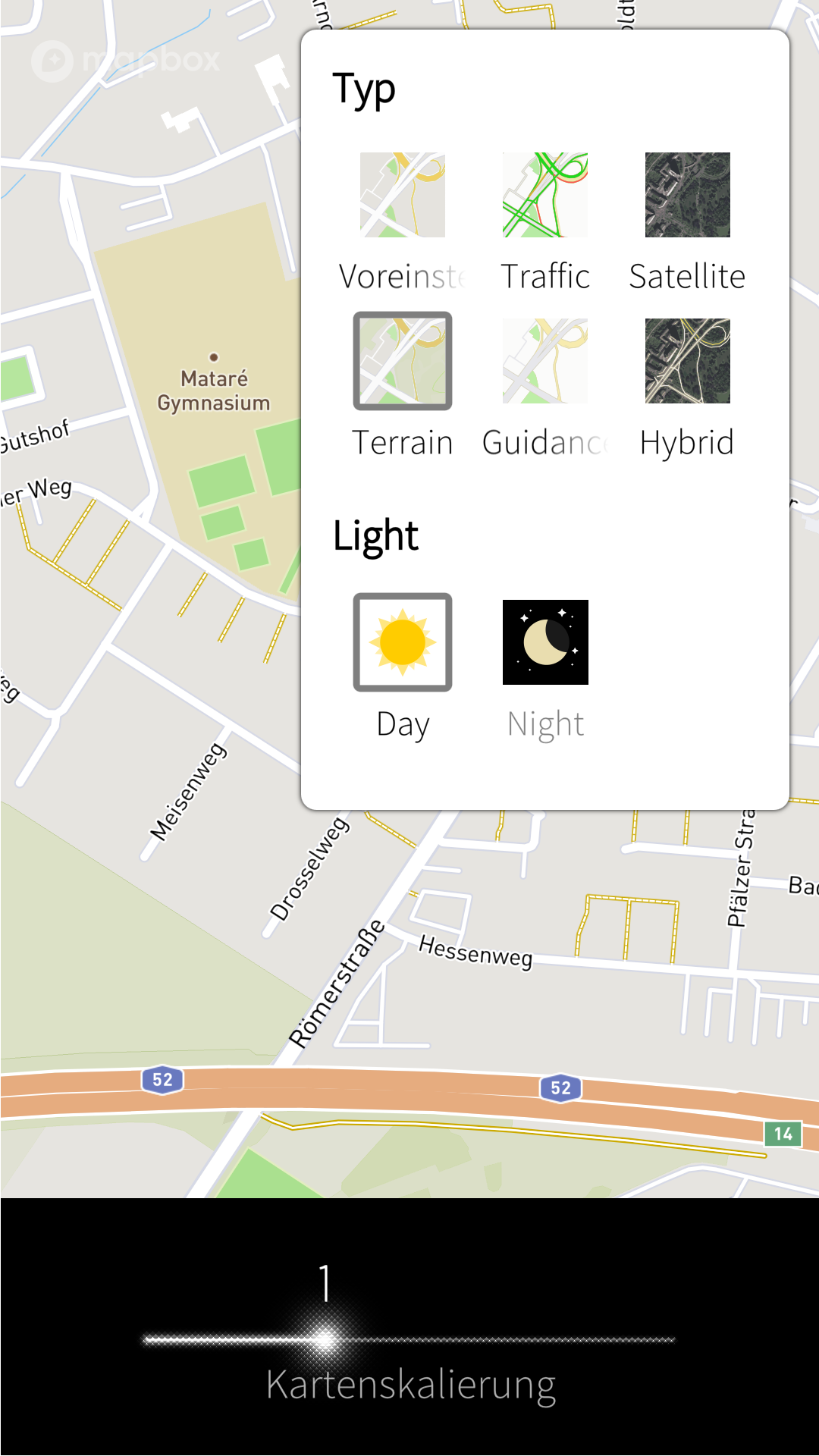
Larger icons to review

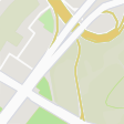
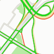


Did not try the vehicle icons.
__________________
Watch our weird watchfaces for mighty AsteroidOS
Performance comparison Video Sailfish 2.0 vs 1.1.9 vs 1.1.7
[MC eV] Maemo Community eV membership application please concider to join!
Watch our weird watchfaces for mighty AsteroidOS
Performance comparison Video Sailfish 2.0 vs 1.1.9 vs 1.1.7
[MC eV] Maemo Community eV membership application please concider to join!
Last edited by mosen; 2019-08-06 at 10:14.
| The Following 9 Users Say Thank You to mosen For This Useful Post: | ||
 |
|
2019-08-06
, 11:33
|
|
Posts: 1,092 |
Thanked: 4,995 times |
Joined on Dec 2009
@ beautiful cave
|
#796
|
Thanx, mosen, looks good. And I don't know, if I would have found some time anyway.
| The Following 5 Users Say Thank You to Fellfrosch For This Useful Post: | ||
|
|
2019-08-06
, 17:36
|
|
Posts: 114 |
Thanked: 381 times |
Joined on Jan 2014
|
#797
|
Originally Posted by mosen
Great work!
https://mosushi.de/misc/puremaps/map...p-standard.png
https://mosushi.de/misc/puremaps/map...ap-terrain.png
I find it a bit hard to differentiate between 1 and 2. A bit more contrast may be, or colour?
| The Following 5 Users Say Thank You to lal For This Useful Post: | ||
|
|
2019-08-06
, 17:55
|
|
Posts: 1,414 |
Thanked: 7,547 times |
Joined on Aug 2016
@ Estonia
|
#798
|
@mosen, nice work, thank you very much! I wonder whether we should have also icons that are shown when the main map is dark. In these conditions we have black / dark surroundings and it would be rather sharp to see these white boxes. But we can deal with it later as well, when light versions are finalized.
| The Following 6 Users Say Thank You to rinigus For This Useful Post: | ||
|
|
2019-08-06
, 18:10
|
|
Posts: 1,414 |
Thanked: 7,547 times |
Joined on Aug 2016
@ Estonia
|
#799
|
Re feedback: yes, I know and I think its a correct place to give this feedback as well. In the end, we all want better maps experience, regardless from which service/frontend it came.
Re sorting results: even if the providers would have the similar interface (which I think they don't), sorting results on Pure Maps side is a bit late. We have received 20 top hits and this "top" would be probably different if the sorting is applied earlier. But taking it as a suggestion
Re history: I suspect is due to non-closure / crashes. It should delete if all works correctly. I'll work on cleaner shutdown, see below
Re battery: well, we have GPS, map matching (if OSM Scout is installed and you see speed limits), finding route point on map by Pure Maps, and probably something else on top of it. In my case (OnePlus X), the charger is charging faster than phone is consuming and I can drive for 6h+ without any problem. Clearly something is too taxing on J1. We could try to test with
* follow me mode with map matching
* follow me mode without map matching
If we would know the battery drain in these conditions and compare that with the full navigation, maybe we can find a major source of battery drain.
Re clear shutdown: indeed, there are more components. I'll look into it ...
 |
|
2019-08-06
, 18:38
|
|
Posts: 4,117 |
Thanked: 8,901 times |
Joined on Aug 2010
@ Ruhrgebiet, Germany
|
#800
|
Thanks mosen for the nice icons.
But I need to agree with lal. More colour/contrast for grren field?
Thanks to pichlo for that detailed report.
Here is a shorter one from my side.
Did use PureMaps in MixedMode (assuming it iy mainly using offline settings). Then I needed to recalculate route and was lost. I crossed border and dod not allow roaming. So no recalculation was made (something like: re-calculation failed). It did not come to my mind as I selected mixed mode and OSM maps in Preferences.
Later on I checked all settings of PureMaps and OSM scout server but could not find the setting of routing engine (pichlo mentioned).
I searched in scout server and PureMaps to no avail.
Only today I tried to acti ate another route and found by accidence that under Navigation there is another settings property via pulley menu called 'Using Stadia Maps'. Went there and voila. Remembered that setting page and set to use OSM for mixed mode.
I expected all settings of PureMaps under Preferences, not under Navigation pulley anymore.
Is that on purpose or a left-over of cleaning up settings?
Second report:
on JollaC my battery was almost emptied after 1 - 1 1/2 h of navigation.
__________________
SIM-Switcher, automated SIM switching with a Double (Dual) SIM adapter
--
Thank you all for voting me into the Community Council 2014-2016!
Please consider your membership / supporting Maemo e.V. and help to spread this by following/copying this link to your TMO signature:
[MC eV] Maemo Community eV membership application, http://talk.maemo.org/showthread.php?t=94257
editsignature, http://talk.maemo.org/profile.php?do=editsignature
The article as a whole makes a very interesting point about how much depends on getting that initial selection right in so much human-facing software. I'm not making any kind of point about PureMaps, which I think is fantastic, BTW. However, given the discussions about UI issues that happen in this thread, I thought it would make an interesting read for some.